Flood Forecast
Forecast Dissemination Procedure
Hydrologic data wirelessly transmitted in real-time from the observation stations are sent automatically to the computer of Yeongsan River FCO. After that, the water level of rivers and flooding scale are calculated for the flood forecasting areas.
When water level rises over defined point, we announce flood-warning or flood-alarm to the public through the mass media (broadcast, newspaper, etc) and related agencies so that citizens can prepare and evacuate against flood.
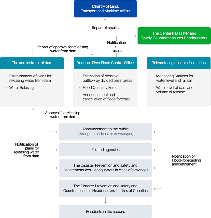
- Ministry of Land, Transport and Maritime Affairs
- ↑ (from Yeonsan River Flood Control Office) Repart of results
- The Centeral Disaster and Sately Countermeasures Headquarters
- → (from Yeonsan River Flood Control Office) Notification of results
-
- ↓ (to Yeonsan River Flood Control Office from The adminstrator of dam ) Repart of approval for releasing water from dam
- The adminstrator of dam
- Establishment of plans for releasing water from dam
- Water Relesing
- ↑ (to The adminstrator of dam from Yeonsan River Flood Control Office) Approval for releasing water from dam
- Yeonsan River Flood Control Office
- Estimation of possible outflow by divided basin areas
- Flood Quantitiy Forecast
- Announcement and cancellation of flood forecast
-
- Telemetering observation station
- Monitoring Stations forwater level and raintall
- Water level of dam andvolume of release
-
(from The adminstrator of dam - 1,2,3) Notification of plans forreleasing waterfrom dam
(from Yeonsan River Flood Control Office - 1,2,3,4) NotifNotification of Flood-forecasting anncuncement
- 1. Announcement to the public (through broadcast or newspaper)
- 2. Related agencies
- 3. The Disaster Prevention and safety and Countemeasures Headquarters in cities of provinces
- 4. The Disaster Prevention and safety and Countemeasures Headquarters in cities of Counties
- Residents in the reqions